Flood Impact Across Pakistan 2025
A Nation Underwater: Pakistan’s Floods in Focus
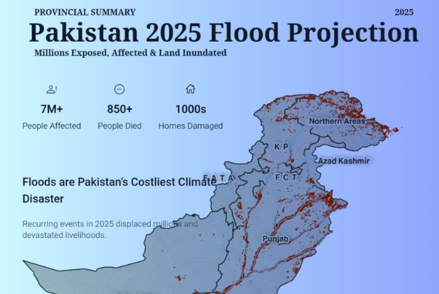
- Punjab: Most exposed province with large population affected by floods
- Sindh: Severely impacted province with widespread inundation
- Khyber Pakhtunkhwa: High flood exposure in northern and river belt areas
- Balochistan: Large land area affected, sparse but vulnerable population
- Gilgit-Baltistan: Mountainous region with flash floods and glacial lake outbursts
- Azad Jammu & Kashmir: River-based flooding, smaller scale compared to other provinces
- Islamabad Capital Territory: Localized flash flooding, limited population exposure
Visual Intelligence by FactsFigs.com
Flood Exposure & Impact Data 2025
Data Source: National Disaster Management Authority (NDMA), Pakistan
Overview
The nation, ranked as the 5th most vulnerable country to climate change by the Global Climate Risk Index, faces an annual battle against water. Pakistan has faced recurring floods in recent years, with devastating impacts on both people and land. From 2022 to 2025, millions of individuals were exposed to floodwaters, while vast agricultural and residential areas were inundated. The severity of these events varied across provinces, highlighting regional vulnerabilities and the urgent need for stronger disaster preparedness.
Understanding Pakistan's Flood Dynamics
The Monsoon Season: Pakistan's Annual Challenge
The South Asian monsoon is the lifeblood of the region's agriculture, but for Pakistan, it is also a source of immense risk. Typically lasting from June to September, these monsoon rains contribute the majority of the country's annual precipitation. The intensity and distribution of this rainfall across the Indus River Basin dictate the severity of riverine flooding, which affects the vast plains of Punjab and Sindh. Compounding this are flash floods in mountainous regions, creating a complex, nationwide hazard profile.
Glacial Melt, Snowpack, and Upstream Water Management
The pre-monsoon season is increasingly critical. Accelerated melting of Himalayan and Karakoram glaciers, which feed the Indus River system, is a major concern. An unusually warm spring can lead to higher-than-normal river flows even before the monsoon arrives, reducing the capacity of rivers and dams to absorb monsoon rainfall. This pre-loading of the river system is a significant early indicator of potential flood severity, requiring close monitoring of snowpack and glacial melt rates in Gilgit-Baltistan.
Conclusion
The floods of recent years have highlighted the scale of vulnerability across Pakistan, exposing millions of people and vast tracts of land to recurring disasters. Provinces like Punjab and Sindh have shouldered the heaviest toll, while regions such as Balochistan and Khyber Pakhtunkhwa continue to face mounting recovery challenges. “Flood resilience is no longer optional — it is essential for Pakistan’s future,” noted a climate risk expert. As climate change accelerates, strengthening infrastructure, improving early warning systems, and investing in adaptation measures will be vital to protect both lives and livelihoods.
Data Source and Attribution
National Disaster Management Authority (NDMA), Pakistan
The data used in this visualization is sourced from NDMA’s official reports, supplemented with figures from UN OCHA and World Bank disaster assessments. It includes provincial breakdowns of people exposed, people affected, and land inundated during major flood events of 2025.
All values are approximate, rounded to the nearest million or thousands people or square kilometer where applicable. Provincial rankings are based on cumulative impact recorded over the covered period.
Last Verified: September 2025
Weekly Updates
Subscribe for the FactsFigs Weekly Brief
Signals, charts, and data stories delivered every week.
More Intelligence
Other Popular Topics
Additional signals from the FactsFigs intelligence feed.

Flood Impact Across Pakistan 2025

Spatial Schooling: The Death of the Textbook